Opis
Add beautiful maps to your WordPress pages with ease. Customize location, map styles, up to two markers, routing and more. Include the map as Gutenberg block, WPBakery Page Builder (formerly Visual Composer) content element or shortcode.
General Settings
This plugin comes with sane predefined settings. Adjust them to your liking. The marker is optional and is not displayed by default.
Map Settings
Map Style Choose the style of the map from one of the available map tile providers to fit your needs.
Map Style Key Enter an API key or access token for the provider depending on the chosen map style. Only required for some map style providers.
Map Height in Relation to Width Change the map’s aspect ratio. Works nicely with responsive designs.
Zoom Level Change the view distance. The higher the number, the closer the distance to the map. (Note: not all styles support all zoom levels).
Zoom With CTRL-Key Only Prevent zooming during page scroll.
Latitude/Longitude of the Map’s Center Specify the map’s center position. Only needed if no marker configured or no marker is set as center of the map.
Activate Routing Activate route planning for the user.
Show Attribution Display or hide attribution for map styles and data. If you disable the checkbox please consider the legal circumstances.
Routing Settings
Default Routing Destination Enter the number of the marker that should be the default routing destination.
Routing Service Choose the routing service that is used for retrieving the routing information.
Routing Key Enter an API key or access token depending on the chosen routing service.
Geocoding Settings
Geocoding Service Choose the geocoding service that is used to translate addresses to latitude and longitude.
Geocoding Key Enter an API key or access token depending on the chosen geocoding service.
Marker Settings
Center map on Enter the number of the marker that should be in the center of the map.
Determine Position By Choose if you want to specify the marker position by an address or coordinates. The marker appears only if you specify an address or coordinates.
Address Insert the marker’s address here with comma separated address parts (only used if you have chosen 'Address’ in previous setting).
Latitude/Longitude Specify marker position with latitude and longitude data (only used if you have chosen 'Coordinates’ in first setting).
Icon The icon to appear on the marker. Subset from Material Icons in outlined style (available categories: Maps, Places, Social).
Color Background color of the marker.
Popup Text Content of the popup that appears if the user clicks on the marker.
Gutenberg
The block is located in the 'Embed’ category and supports the wide and full width options.
WPBakery Page Builder
The content element for the map can be found on the 'Content’ tab with the name 'SBS OpenStreetMap’. The content element for the marker can also be found on the 'Content’ tab with the name 'SBS Openstreetmap Marker’ but only as child of the map element.
Shortcodes
The Plugin comes with two shortcodes: [sbs_openstreetmap] for the map and [sbs_marker] for the markers (need to be placed between the opening and closing tags of the map shortcode).
If parameters are not specified, the defaults are used (the same as in the other components). The popup text for the marker can be specified between the opening and closing tags of the marker shortcode.
Parameters Map Shortcode
See section 'General Settings’ for description. Name in parentheses is the entry there.
map_style (Map Style)
Choose provider and style variant and define map_style as 'provider.variant’ (eg. Thunderforest.Transport) or in case of a provider without variants just 'provider’ (eg. OpenTopoMap) . (pay attention to upper and lower case)
Available Provider with Variants:
OpenStreetMap — Variants: DE (default), Mapnik, France, HOT
OpenTopoMap
Stamen — Variants: Toner, TonerLite, Terrain, Watercolor
Stadia — Variants: AlidadeSmooth, AlidadeSmoothDark, Outdoors, OSMBright
Thunderforest — Variants: OpenCycleMap, Transport, TransportDark, SpinalMap, Landscape, Outdoors, Pioneer, MobileAtlas, Neighbourhood
MapBox — Variants: Streets, Outdoors, Light, Dark, Satellite
CartoDB — Variants: Positron, DarkMatter, Voyager
MapTiler — Variants: Basic, Bright, Pastel, Positron, Hybrid, Streets, Toner, Topo, Voyager
For more information see section 'Map Styles’.
map_style_key (Map Style Key) Needed for certain map providers.
map_height (Map Height in Relation to Width) Use a number as percentage of the width. Default value is 50.
zoom (Zoom Level) Number between 0 and 20. Default value is 15.
ctrl_mouse_zoom (Zoom With CTRL-Key Only) Set to true or false. Default is false.
latitude (Latitude of the Map’s Center)
longitude (Longitude of the Map’s Center)
routing (Activate Routing) Set to true or false. Default is false.
show_attribution (Show Attribution) Set to true or false. Default is true.
destination_marker (Default Routing Destination) Number of the marker shortcode based on order inside the map shortcode. 0 if no marker is supposed to be the default routing destination. Default is 1.
router (Routing Service) Available values:
osrmv1 (default)
mapbox
router_key (Routing Key) Needed for certain routing services.
geocoder (Geocoding Service) Available values:
nominatim (default)
mapbox
geocoder_key (Geocoding Key) Needed for certain geocoding services.
center_marker (Center Map on) Number of the marker shortcode based on order inside the map shortcode. 0 if no marker is supposed to be the center of the map. Default is 1.
Parameters Marker Shortcode
See section 'General Settings’ for description. Name in parentheses is the entry there.
marker_source (Determine Position By) Available values:
address (default)
coordinates
marker_address (Address)
marker_latitude (Latitude)
marker_longitude (Longitude)
marker_icon (Icon) CSS classes for the icon. Go to the Material Icon website and choose your desired icon. To get the CSS classes, use the icon’s name, replace the underscore with a hyphen and prepend 'sbs-map-icon sbs-map-’. Example: icon 'local_airport’ becomes 'sbs-map-icon sbs-map-local-airport’
marker_color (Color) Available values:
red
white
dark_blue (default)
green
black
orange
yellow
Examples:
[sbs_openstreetmap][sbs_marker][/sbs_marker][/sbs_openstreetmap]
Uses default values
[sbs_openstreetmap center_marker="1"][sbs_marker marker_source="coordinates" marker_color="green" marker_latitude="52.4681196" marker_longitude="13.3279639" marker_icon="sbs-map-icon sbs-map-my-location"][/sbs_marker][/sbs_openstreetmap]
Green marker from coordinates with my_location icon, centered map at marker and no popup text
[sbs_openstreetmap map_style="Stamen.Terrain" map_height="30" zoom="14" ctrl_mouse_zoom="true"][sbs_marker marker_color="dark_blue" marker_address="Bundesallee 87, 12161 Berlin" marker_icon="sbs-map-icon sbs-map-beenhere"]Popup Text[/sbs_marker][/sbs_openstreetmap]
Stamen Terrain style, Zoom with CTRL key only, dark blue marker from address with popup text
[sbs_openstreetmap map_style="MapBox.Streets" map_style_key="<your access token>"][/sbs_openstreetmap]
Mapbox Streets style that needs an access token
[sbs_openstreetmap zoom="12" latitude="52.493558" longitude="13.375148" center_marker="0"][sbs_marker marker_address="Bundesallee 87, 12161 Berlin"]Marker 1[/sbs_marker][sbs_marker marker_address="Platz der Republik 1, 10557 Berlin"]Marker 2[/sbs_marker][/sbs_openstreetmap]
Two markers with different addresses, center of the map somewhere in between through coordinates
Map Styles
The selectable styles are offered by various providers. Each provider has its own terms of use and licensing, which should be taken into account before using the styles. (See section 'Licenses/Policies’ for links)
Providers could change their terms of use or might not be available at all times (especially if they are free/ without registration).
Providers
OpenStreetMap
Usable without registration.
Variants: DE, Mapnik, France, HOT
Examples: De, Mapnik, France, HOT
OpenTopoMap
Usable without registration.
Example
Stamen
Usable without registration.
Variants: Toner, TonerLite, Terrain, Watercolor
Examples
Stadia
In order to use Stadia maps, you must register and whitelist your domain within your account.
Variants: AlidadeSmooth, AlidadeSmoothDark, Outdoors, OSMBright
Examples
Thunderforest
In order to use Thunderforest maps, you must register. Once registered, you get an API key to use for the map styles.
Variants: OpenCycleMap, Transport, TransportDark, SpinalMap, Landscape, Outdoors, Pioneer, MobileAtlas, Neighbourhood
Examples
MapBox
In order to use MapBox maps, you must register. Once registered, you get an access token to use for the map styles.
Variants: Streets, Outdoors, Light, Dark, Satellite
Examples
CartoDB
Basemaps are usable without registration.
Variants: Positron, DarkMatter, Voyager
Examples
MapTiler
In order to use MapTiler maps, you must register. Once registered, you get an API key to use for the map styles.
Variants: Basic, Bright, Pastel, Positron, Hybrid, Streets, Toner, Topo, Voyager
Examples
Deprecated
These values are deprecated and will be mapped onto the corresponding new values for the same map style.
openstreetmap_de
opentopomap
stamen_toner
stamen_toner_light
stamen_terrain
stamen_watercolor
wikimedia (not available anymore and if set in map, will be replaced with OpenStreetMap.DE)
Licenses/Policies
External Services
Provides the map data
OpenStreetMap ODbL
Providers for routing
OSRM Demo Server Usage policy
Mapbox Terms of service
Providers for geocoding
Nominatim Usage policy
Mapbox Terms of service
Providers used for choosable map styles
OpenStreetMap Terms of use
OpenTopoMap CC-BY-SA/Terms of use
Stamen CC BY 3.0/Terms of use
Stadia Terms of use
Thunderforest Terms of use
MapBox Terms of use
CartoDB Terms of use
MapTiler Terms of use
Third-Party Components
Leaflet JS BSD 2-Clause „Simplified” License
Leaflet.GestureHandling MIT License
Leaflet-providers BSD 2-Clause „Simplified” License
Leaflet-control-geocoder BSD 2-Clause „Simplified” License
Leaflet-routing-machine ISC License
Only used in Gutenberg Editor
React FontIconPicker MIT License
prop-types MIT License
Classnames MIT License
react-transition-group BSD 3-Clause License
Zrzuty ekranu

Multiple map styles 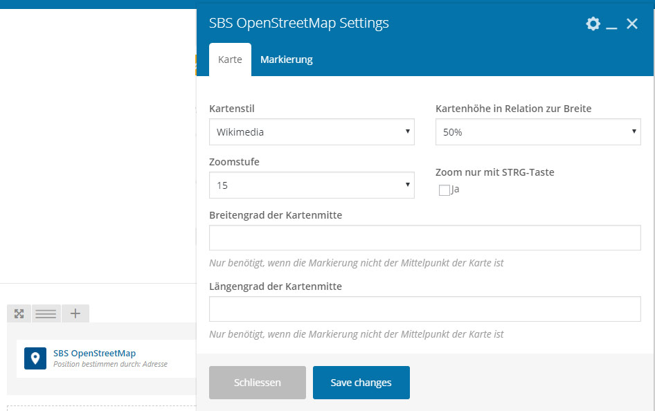
WPBakery Page Builder 
Gutenberg
Bloki
Wtyczka dodaje 1 blok.
- OpenStreetMap
Instalacja
Notes:
* the Gutenberg block requires WordPress 5.2 or higher
* the WPBakery Page Builder content element requires an active WPBakery Page Builder plugin
- Upload the StepByteService OpenStreetMap plugin to the '/wp-content/plugins’ directory.
- Activate the plugin.
- Use one of the components to add maps to your pages.
Najczęściej zadawane pytania
-
The map does not show properly
-
Wikimedia changed its terms of use and is not available as provider anymore. If the chosen map style was wikimedia it is automatically changed to OpenStreetMap.De. You can always choose a different style.
If there are graphical errors, first check if a different zoom level changes anything. Not all map styles support all zoom levels and while most should just show a different zoom level if they don’t support the chosen one, there might be parts of the map which are not shown on other styles.
In case the map is placed on a container that is not visible initially (f.e. using tabs or accordions), you’ll have to trigger the eventinvalidate.sbs.openstreetmapin JavaScript once the element becomes visible to redraw the map. If you’re using Bootstrap or WP Bakery Page Builder tabs or accordions, this is handled by the plugin itself.
Recenzje
Kontrybutorzy i deweloperzy
„OpenStreetMap for Gutenberg and WPBakery Page Builder (formerly Visual Composer)” jest oprogramowaniem open source. Poniższe osoby miały wkład w rozwój wtyczki.
ZaangażowaniInteresuje cię rozwój wtyczki?
Przeglądaj kod, sprawdź repozytorium SVN lub czytaj dziennik rozwoju przez RSS.
Rejestr zmian
1.1.2
- Fixed escaping
1.1.1
- Fixed Gutenberg Migration
1.1.0
- Removed params api_key and access_token in favor of new param map_style_key
- Added routing option
- Added geocoding option
- Added support for up to 2 markers
- Updated dependencies
- Fixed error with widget editor
- Reduced amount of geocoding requests in gutenberg editor
1.0.10
- Added new provider options
- Removed Wikimedia map style
1.0.9
- Updated dependencies
1.0.8
- Wikimedia map style not default anymore
1.0.7
- Fixed check for WPBakery Page Builder events
1.0.6
- Fixed marker
1.0.5
- Internet Explorer 11 fixes
1.0.4
- Fixed marker icon selection in WPBakery Page Builder backend editor
1.0.3
- Fixed notice in WordPress debug mode
1.0.2
- Improved asset loading
- Fixed WPBakery Page Builder frontend editing
1.0.0
- Initial release